Article Overview:
The article explains what 3D laser scanning in construction is and how it transforms the way project managers, engineers, and developers capture and verify site data. It outlines how Apex Geomatics Construction Surveyors Ltd. uses advanced LiDAR and land surveying equipment to produce precise 3D models for as-built documentation, clash detection, and design verification. Readers will learn how this technology improves accuracy, saves time, reduces rework, and enhances coordination across project teams, delivering verified digital data that supports smarter, more efficient construction from start to finish.
Modern construction relies on precision. From industrial facilities to commercial developments, project managers and engineers depend on reliable spatial data to make decisions and prevent costly rework. If you have ever wondered what is 3D laser scanning in construction, it is one of the most advanced measurement technologies available today, delivering highly accurate, detailed, and actionable data in a fraction of the time required by traditional methods.
What Is 3D Laser Scanning in Construction?
3D laser scanning is a surveying method that uses LiDAR (Light Detection and Ranging) technology to collect millions of spatial data points from a structure or site surface. These points form a detailed “point cloud,” which can be used to create accurate 3D models of existing conditions. For construction, these models become essential references for design validation, progress tracking, and as-built documentation.
Unlike traditional surveying, which records discrete points manually, laser scanning captures a continuous digital representation of the site. This approach eliminates gaps in data, minimizes human error, and produces a full record of existing site geometry, ideal for complex projects where precision and documentation are critical.
How 3D Laser Scanning Works
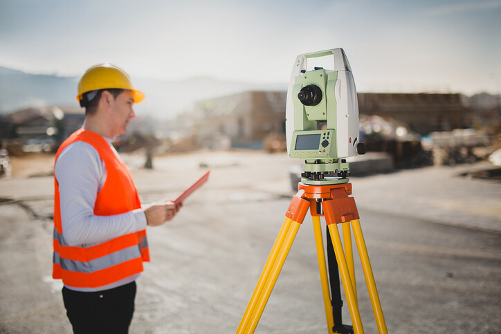
Surveyors set up laser scanners, specialized land surveying equipment, on tripods or mobile mounts throughout the job site. The scanner emits a laser beam that measures distances to surrounding surfaces, recording millions of points per second. Each scan is then registered and combined to form a complete 3D dataset of the area.
These point clouds are processed into digital surface models or integrated with CAD and BIM environments. Engineers, architects, and project managers can then view accurate representations of the site, compare designs to actual field conditions, and identify potential clashes before they become costly problems.
Applications of 3D Laser Scanning in Construction
3D scanning has become an integral part of modern surveying workflows. Apex Geomatics applies this technology across a wide range of applications, including:
- As-built documentation: Capturing exact existing conditions to verify completed work and maintain permanent project records.
- Clash detection: Identifying conflicts between structural, mechanical, and electrical systems before installation.
- Design verification: Comparing construction progress to design models for accuracy and alignment.
- Retrofit and renovation planning: Creating detailed base models for upgrading existing facilities without relying on outdated drawings.
- Volume and deformation analysis: Measuring stockpiles, slopes, or structural movement with millimeter-level precision.
These applications help project managers and engineers make informed decisions quickly, reducing risk and keeping projects within scope and schedule.
The Benefits of 3D Laser Scanning in Construction
The benefits of 3D laser scanning in construction extend across safety, quality, and efficiency. By capturing complete, high-resolution data, surveyors eliminate the need for repeated site visits and manual re-measurements. This not only saves time but also reduces exposure to active or hazardous environments.
Accuracy is another major advantage. Scans routinely achieve millimeter-level precision, allowing engineers to detect even the smallest deviations before they escalate into significant issues. The resulting digital models enable seamless coordination among design, fabrication, and construction teams. With shared access to verified data, every stakeholder works from the same reliable source of truth.
For project managers, this translates directly into cost control and schedule confidence. 3D laser scanning has proven to significantly reduce rework costs and accelerate field verification, allowing measurement and quality assurance tasks that once took days to be completed in just a few hours. When integrated into broader survey operations, it becomes an indispensable tool for delivering data that drives decisions.
Real-World Impact: Time Savings and Risk Reduction
Consider a commercial facility expansion requiring integration of new structural steel with existing utilities. Using traditional methods, verifying tie-in points and clearances could take multiple days and introduce measurement uncertainty. With 3D laser scanning, Apex Geomatics can capture the entire area in a few hours, deliver a fully registered point cloud, and provide clash analysis within a day.
This process allows engineers to identify interferences virtually before work begins, preventing costly field modifications. The same approach supports as-built verification, ensuring that completed installations match design intent exactly. For developers and site leads, these efficiencies translate into measurable savings, fewer delays, and stronger documentation for quality assurance.
Why 3D Laser Scanning Is the Future of Construction Surveying
As construction projects become larger and more complex, the demand for accurate, real-time data continues to grow. 3D laser scanning meets this need by combining speed, accuracy, and digital integration. It not only enhances traditional surveying practices but also creates a foundation for future technologies such as digital twins and automated progress monitoring.
For Apex Geomatics, 3D scanning is more than a service, it is part of a commitment to precision-driven surveying. By combining advanced land surveying equipment with field expertise, Apex Geomatics ensures that every scan delivers reliable, actionable data to clients who depend on accuracy.
Build Smarter with Verified Digital Precision
To answer the question what is 3D laser scanning in construction: it is the technology that gives project managers complete confidence in every measurement and decision. From as-built documentation to design verification and clash detection, it streamlines workflows, reduces risk, and ensures every phase of construction aligns with the plan.
For a closer look at the professionals who make these results possible, read our next article: What Do Land Surveyors Do? A Practical Guide for Construction Project Managers to understand their role in layout, site preparation, and real-time data accuracy.
Contact Apex Geomatics Construction Surveyors Ltd. to partner with a team that ensures your next development begins with verified boundaries, field-ready layout, and precision you can build on.